
Priority 3: Priority Area Lens 1 (Floods)
Pittsburgh Water and Sewer Authority (PWSA)
2022 Stormwater Strategic Plan (SWSP)
PWSA released a strategic plan in December of 2022. The public has until June 30, 2023, to comment on this document and submit those ideas/concerns/questions for official review. The Mon Water Project is going to step through each Priority and provide insight.
Lens 1: Localized Flooding
Priority 3 of the Plan includes a lot of important data, analysis, and parameters used in the plan to determine the next steps. These layers of information are called lenses. We are going to evaluate each lens individually.
What the plan says:
“While investments in flooding are needed throughout Pittsburgh, new flood control projects must be directed toward areas with the most widespread, severe, and persistent flooding problems. Additionally, new resources must be allocated to enhance mapping and modeling of where, how often, and how much flooding is occurring, down to the individual impacts.”
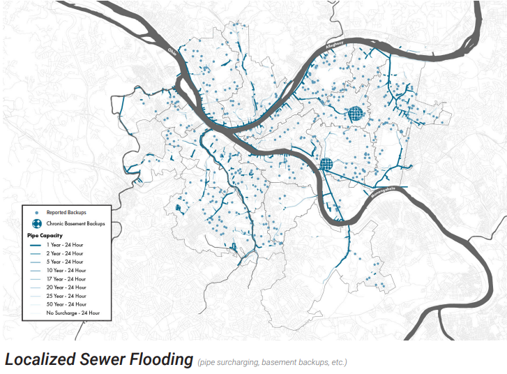
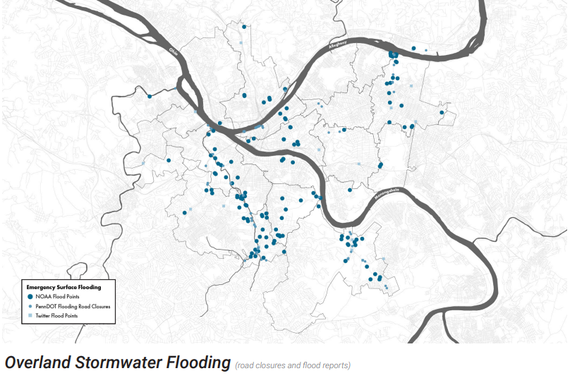
Fun Fact: Pittsburgh has no centralized mapping system or method to analyze flooding. As a result, in order to even develop this lens, they had to piece together many sources of data including: FloodFactor (now https://riskfactor.com/), Twitter reports, PennDOT Road Closure notices, and modeling (computer simulations) where pipes surcharge (overflow), and lastly calls into PWSA of backups by residents.
The results are summarized in maps.
Map 1: Localized Sewer Flooding
Map 2: Overland Stormwater Flooding
What I think:
FOR THE LOVE OF ALL THINGS HOLY…watch out, this one has me fired up.
The most important action from this ENTIRE PLAN is hidden here in Lens 1. THIS IS A CALL TO ACTION! PWSA must immediately develop a comprehensive and authoritative map of flooding for the City of Pittsburgh. I think it needs to be universally approved, implemented, and USED by all members of the Task Force (other city agencies (priority 2)). This mapping must create a ROBUST and EXTENSIVE real-time understanding of flooding in the city. Next, applying that data to a calibrate the predictive model used to determine problem areas.
PWSA can take it step further by using the already available ALCOSAN Rain Gauge Network in our area that allows us to see real time rainfall in Allegheny County. PWSA must establish a understanding of “what rain causes what issues and where” and watch for those systems as they move through Pittsburgh. Allowing us to transition to a PROACTIVE agency, PWSA can develop a flood warning system, that utilizes customer contact data, and alerts individuals to the potential localized flooding coming their way.
Expand this further, they communicate those warning to the public with specific areas of concern. For example, PWSA could help local news stations understand incoming storm’s potential and how they anticipate flooding emergencies. Take your info to the public where they already get it, so when KDKA gives a weather report and general warnings, they can now include areas of localized flooding and specific notifications. Communication of this data doesn’t stop there. Finally, PWSA must develop visualizations and simulations of flooding after they happen, so the public can understand what storms could mean for their property.
Image if neighbors in the run were given time to move things from their basements and protect their cars and property? At least give us a chance, while we wait for 30 years solutions and plans of plans.
This request is stated with urgency. Climate Change in Pittsburgh will look like HARDER STORMS, with MORE RAIN, MORE OFTEN. Science and engineers have proven this. So… Flood-level rain is our future. OUR ONLY mechanism to understand things as they begin to change quickly, is to have these mapping and analysis tools in place. Climate Change is a public health emergency. Protection and warning systems are the first line of defense. The urgency for this tool can not be overstated.
Lastly, not enough people know to call PWSA when they have basement flooding or see flooding in the street. Often we are just resigned to our fate and this system failure. If we are going to use this reported data in the plan, we must understand historical issues around reporting and equity/racism in our city. “Squeaky wheels always getting grease” needs to stop. Disenfranchised neighborhoods and communities of color are always disproportionately missing from this reporting data. Using Priority 1 PWSA Communications strategies, PWSA must increase public awareness of this important reporting mechanism.
Priority 3 is the development of priority watersheds, and these flood based tools will allow PWSA to truly meet the mission of this section: where to spend money. Allowing us to find and track the REAL SOURCE of the flooding within a sewer system allows us to truly prioritize projects and areas of need!
Everything I just said is already technologically possible today and based on data we already have.
So there is no excuse for us, AS A CITY, to rely on a social media platform for flooding notifications. So there is no reason for us, AS A CITY, to be completely SHOOK when flooding occurs. We must hold our leadership accountable for historically acting reactively. We can no longer believe proactive actions are impossible.
They are possible and they are necessary.
Seriously, Pittsburgh, SERIOUSLY. Build the map. Use the Map. NOW!
Summary:
An additional analysis needs to be completed that evaluates the location of flooding in relation to houses and neighborhoods. How many of the flood “bowls” (geographical and geological depressed areas) are located within residential neighborhoods? Schools? Bus stops? Not all flooding is equal. Areas where flooding directly impacts landowners needs to be weighted higher, to account for the human health emergency that flooding creates.
PWSA must immediately develop (in coordination with the Task Force) a reporting mechanism for flood reporting in the City of Pittsburgh.
The distribution of localized and overland known flooding events in the upper monongahela (Hazelwood Neighborhood) watershed is unknown, not nonexistent like the plan map suggests. Since data is based on reporting, a system in which the “squeaky wheel gets the grease”. This cycle has structurally and institutionally perpetuated the disinvestment in communities of color and low income neighborhoods. Localized flooding issues in this area are unknown and need additional instigation and evaluation. Areas with a lack of data should be weighted higher/differently due to this information gap.
How was this category evaluated including climate change adjustments and future flow conditions?